|
| | (2002年7月7日)美國德克薩斯州
中南部遭遇歷來最嚴重的洪災。7月1日開始的暴雨,已造成8人死亡,四千多人無家可歸。
美國國家氣象局表示,德州許多地區的降雨仍會持續數天。(details
below)
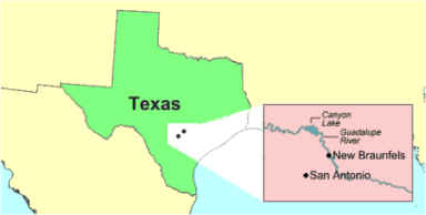
在聖安東尼奧市東北面的峽谷湖水位45年來首次超過溢洪道,洶湧的洪水匯入已經泛濫成災的瓜達盧普河,衝進新布朗費爾斯鎮,將數百房屋衝塌。
德州中部還有許多小村鎮被洪水圍困,100多條道路被堵塞。美國總統布殊星期四宣佈德州10個縣為受災縣,並獲得聯邦政府的援助。
|
(JUL 7, 2002) The worst flood in
history severely hit the central-south area of Texas, US. Heavy rain since
July 1 has claimed 8 deaths and made 4000 homeless.
Rain will persist for several days according to the National Weather
Service. (details
below)
Water levels at the Canyon Lake Dam northeast
of San Antonio were above the spillway for the first time in 45
years, and flood water was pouring into the flood-stricken
Guadalupe River, rushing into the town of New
Braunfels and causing damages to hundreds of houses.
President Bush declared 10 counties federal disaster areas on Thursday,
making them eligible for federal relief funds.
|
FLASH
FLOOD STATEMENT (abstract)
source:
National Weather Service Forecast Offices, US
NATIONAL
WEATHER SERVICE AUSTIN/SAN ANTONIO TX 810 PM CDT JUL 6 2002
HILL COUNTRY AND ADJACENT AREAS OF CENTRAL AND SOUTH CENTRAL TEXAS
| A
flash flood watch will be in effect tonight and Sunday morning. This area
is extremely prone to the effects of additional heavy rain and flooding
since most of the heavy rainfall the past week has occurred over the hill
country. Scattered showers and thunderstorms will persist through the late
evening and early morning hours and produce additional rainfall amounts
which could add to the already high totals affecting the Guadalupe and
Medina river watersheds. This remains a dangerous and life-threatening
river flood situation. Just because the shower and thunderstorm activity
has abated somewhat, please do not think the river flood event is over. In
some areas, it is just beginning and will continue well into next week,
especially those locales downstream on the Guadalupe, Medina and San
Antonio rivers. |
|